2018-02-07 |
Drone Technology has a Multitude of Applications for Farmers
The use of drone technology for farming and land management is becoming increasingly relevant and widespread, but further regulation now in the offing.
On the farm, drones provide a valuable new technology for surveying, monitoring and mapping with other features in development for other functions coming fast over the horizon.
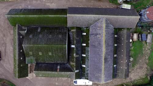
Drone survey of farm roofing
Photography courtesy Graymatter Media
But new technology brings with it a bundle of new risks and responsibilities and Baroness Sugg, Parliamentary Under Secretary of State for Transport announced a number of new measures last November that are expected to come into force this year.
Drone operation, with or without a camera, raises issues of privacy, can cause nuisance and disturbance, and, in the event of failure, recklessness, or incompetence, can cause potential damage to individuals, property and stock for example.
The Civil Aviation Authority has published a Drone Code (dronesafe.uk) and this year will see the introduction of new laws, guidance, permissions and licensing in relation to different sizes, weights and professional and recreational use of drones. The draft Drone Bill is proposed for this spring. There is recognition that any necessary restrictions however should not stifle the potential for development of drone technology or its many applications on a global scale, a field in which the UK is acknowledged to be among the leaders.
Currently anyone operating a drone commercially must have a Permission for Commercial Operation (PfCO) from the CAA, having completed a course and demonstrated the required level of airmanship, and being properly insured.
For recreational use, no drone can be flown within 150m of a congested area (ie only over empty countryside), or within 50m of any person or object not within the operator’s control.
The following measures have been proposed:
-
That any drone of more than 250 grams will require to be registered.
-
That all drones should be electronically identifiable.
-
That all drones fitted with cameras would be regulated and need permission to be flown from the CAA.
Mike Jones, senior manager at Saffery
Champness and a member of the firm's
Landed
Estates and Rural Business Group says:
From a tax and management perspective, farms and estates can use this technology
to provide photographic or video evidence of properties which can assist with
tenancy issues as well as being useful in monitoring repairs carried out on
property. They can also be used to provide evidence to support claims for repair
expenditure or capital allowances in dealings with HMRC. Evidence provided
by drones has also assisted with ensuring that adequate and realistic insurance
cover is in place which has led to significant reductions in premiums in some
cases.
If developed in house, the purchase of such equipment will qualify for capital allowances and therefore the cost is relievable for tax purposes. Furthermore, there may be opportunities for incorporated businesses to benefit from research and development tax credits if they can show that expenditure has been incurred in devising novel uses and applications of drone technology.
With regard to its practical applications, Mark Coombs, Estate Manager, Brudenell
Estates, says:
Brudenell Estates is a mixed agricultural, residential and commercial
portfolio comprising approx 10,000 acres and we have used drone technology
commissioned through Estate Asset Capture and Graymatter Media to great effect.
They have surveyed all of our built assets and these are now linked into our
Landmark Estate Terrier System. The imagery, which comprises both 3D models,
and orthomosaic mapping and 360 degree photos allow us immediate access to
the property - remotely. When linked with the Estate Terrier, this has proven
invaluable in a number of areas including planning applications, presentation
to communities, insurance schedules, risk assessments for health and safety
and, in our case, assisted in our IHT exemption documentation. Importantly,
it has also saved management time and expense when examining repairs that are
often inaccessible without ladders and scaffolding.
It should be noted that a land owner or farmer using a drone to survey their own property, for example for insurance purposes or damage claims, would require a PfCO under current legislation.
